Back Sabaneta (Antioquia) AVK Sabaneta Catalan Sabaneta (munisipyo sa Kolombiya, Departamento de Antioquia, lat 6,13, long -75,63) CEB Sabaneta (Kolumbien) German Σαμπανέτα (Κολομβία) Greek Sabaneta Esperanto Sabaneta (Colombia) Spanish سابانتا (انتیوکیا) Persian Sabaneta (Antioquia) French Sabaneta Scots/Gaelic
This article needs additional citations for verification. (March 2023) |
Sabaneta, Antioquia | |
|---|---|
Municipality and town | |
 | |
 Location of the municipality and town of Sabaneta, Antioquia in the Antioquia Department of Colombia | |
| Coordinates: 6°09′N 75°36′W / 6.150°N 75.600°W | |
| Country | |
| Department | |
| Founded | 1903 |
| Government | |
| • Mayor | Santiago Montoya |
| Area | |
| • Municipality and town | 15 km2 (6 sq mi) |
| • Urban | 4.53 km2 (1.75 sq mi) |
| Elevation | 1,550 m (5,090 ft) |
| Population (2018 census)[1] | |
| • Municipality and town | 82,375 |
| • Density | 5,500/km2 (14,000/sq mi) |
| • Urban | 70,401 |
| • Urban density | 16,000/km2 (40,000/sq mi) |
| Demonym | Sabaneteño |
| Time zone | UTC-5 (Colombia Standard Time) |
| Area code | 57 + 4 |
| Website | Official website (in Spanish) |
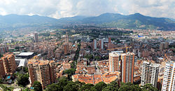
Sabaneta is a municipality of Colombia, located in the Aburrá Valley of the Antioquia department. It is bordered on the north by the municipalities of La Estrella, Itagüí and Envigado, on the east by Envigado, on the south by Caldas, and on the west by La Estrella.
It is the smallest municipality in Colombia, with an area of only 15 km2. It is known as the Municipio Modelo de Colombia ("Model Municipality of Colombia") or the Vallecito de Encanto ("Charming little Valley"). The municipality owes its name to the diminutive "sabana," a Spanish word meaning "savannah".[citation needed]
The population receives an influx of visitors on the weekends because of its reputation for having outstanding entertainment venues.
- ^ Citypopulation.de Population of Sabaneta municipality with localities


